


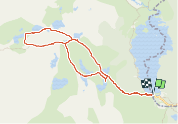
mon tour des lacs de bouillouse

stef789
User GUIDE

Length
11.4 km

Max alt
2353 m

Uphill gradient
386 m
Km-Effort
16.6 km

Min alt
2005 m

Downhill gradient
386 m
Boucle
Yes
Creation date :
2024-10-28 11:15:24.368
Updated on :
2024-10-28 16:43:51.004
5h27
Difficulty : Medium

FREE GPS app for hiking
 SityTrail
IGN / Geographical institutes
SityTrail Plus
The world is yours!
About
Trail Walking of 11.4 km to be discovered at Occitania, Pyrénées-Orientales, Les Angles. This trail is proposed by stef789.
Description
les lacs de bouillouse, vivé, dougnes, trebens, soubarian, bailleul, sec, coumasse, noir
Photos


41 photos in total. Please click on a photo to see them all in the gallery.
Positioning
Country:
France
Region :
Occitania
Department/Province :
Pyrénées-Orientales
Municipality :
Les Angles
Location:
Unknown
Start:(Dec)
Start:(UTM)
417990 ; 4712417 (31T) N.
Comments